Local Attractions in Chikmagalur
Chikmagalur is situated in south western part of Karnataka. Chikmagalur literally means "The town of the younger daughter" in the Kannada language. The district is named after its headquarters town of Chikmagalur. The major commercial crop is coffee. The hill stations around Chikmagalur are famous summer retreats since they remain cool even during summers. Mullayanagiri, the highest peak in Karnataka is 12 Kms away from Chikmagalur. The district is dotted with many holy spots and tourist places. Number of rivers originates from the hills of Chikmagalur district and flow in all the seasons. PLACES OF INTEREST IN CHIKMAGALUR
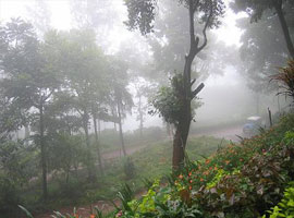
Kemmangundi
55 km north from Chikmagalur town is Kemmangundi, a scenic hill station on the Baba Budan Giri range of hills. Kemmangundi is also known as K.R. Hills after the Wodeyar King, Krishnaraja Wodeyar, who had made it his favourite summer camp. Kemmangundi, at a height of 1,434 meters, is surrounded by thick forests and a salubrious climate through out the year. It is surrounded by the Baba Budan Giri range and blessed with silver cascades of mountain streams and lush vegetation. Its beautifully laid out ornamental gardens and enchanting mountain and valley views are a treat to the eye. Spectacular sunsets are a must see from various locations in the district, even from the Raj Bhavan. For the adventurous, Kemmangundi offers many peaks to scale and intricate jungle paths to explore. This place has a beautiful rose garden and other attractions. There is a place called Z-point at about 10 minutes walk from this main place which gives a nice arial view of the Shola grass lands of the Western Ghats.
Kudremukh and National Park
95 km southwest of Chikmagalur town is Kudremukh range (in Kannada Kudure = horse and mukha = face), so named because of the unique shape of the Kudremukh peak. Overlooking the Arabian sea, the broad hills are chained to one another with deep valley & steep precipices. Situated at 1,894.3 meters above sea level, Kudremukh is rich in iron ore deposits. The Kudremukh Iron Ore Company conducts mining operations, benefaction and transportation of the ore as slurry through pipelines to the port at Panambur near Mangalore.
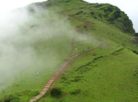
Mullayanagiri
Mullayanagiri is part of the Baba Budan Giri Hill Ranges here. It stands 1930 meters tall and is the tallest peak in Karnataka. Its height is famous mostly for watching sunsets from. It is 16 km from Chikmagalur town. Driving to Mullayanagiri is worth taking a risk. On the way is Sitalayanagiri where the water in the Shiva temple neither increases nor decreases. The road to Mullayanagiri is very narrow with a views from steep cliffs. Driving to the peak is not possible and includes a trek up the hill from the half way point. There is a small temple on top of the hill. From the topmost point of the hill the Arabian sea is visible on clear days. The small hillock in the temple compound is the highest point in Karnataka. The narrow road to the temple makes two way traffic immpossible. It is a great trekking spot in Karnataka.
Datta peeta (Baba Budan Giri)
To the north of Chikmagalur town is the Baba Budan Giri Range or Chandra Drona Parvatha as it was known in the ancient times, which has one of the highest mountain peaks between the Himalayas and the Nilgiris. The peak takes its name from the Muslim saint, Baba Budan, who resided here more than 150 years ago.
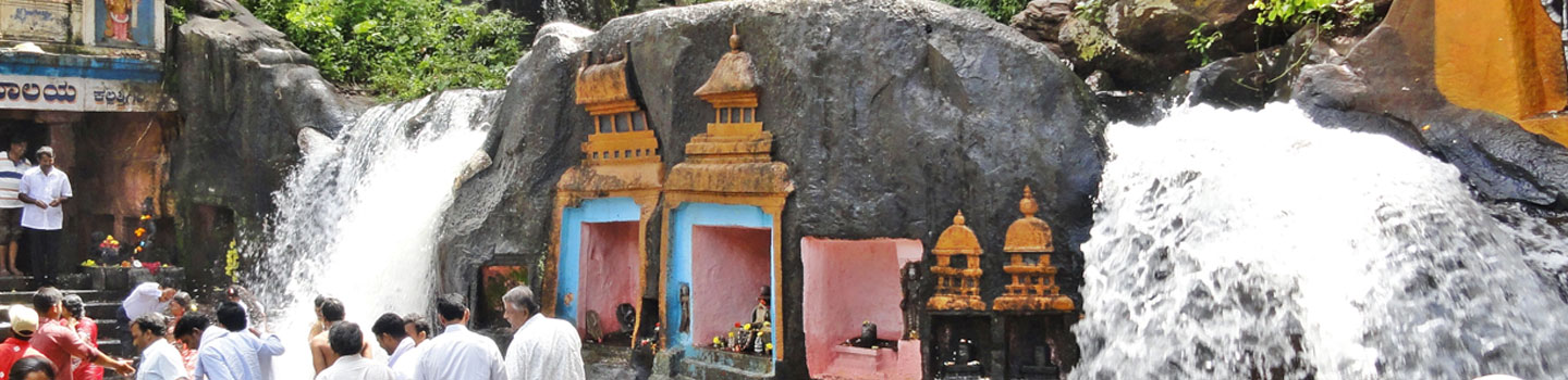
Kallathigiri Falls
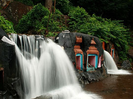
Just 10 km away from Kemmangundi is Kallahathigiri falls, also known as Kalahasti falls. Water cascades down from the top of the Chandra Drona hill from a height of 122 meters amidst fascinating scenery. There is an old Veerabhadra temple dedicated to Lord Shiva, constructed in a gap between rocks. This temple can be approached after crossing the waterfall.
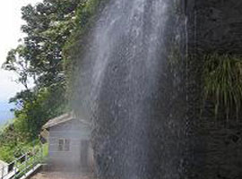
Hebbe Falls: This beautiful waterfall is over 10 km away from the famous hill station, Kemmangundi. Here water streams down from a height of 168 meters in two stages to form Dodda Hebbe (Big Falls) and Chikka Hebbe (Small Falls).
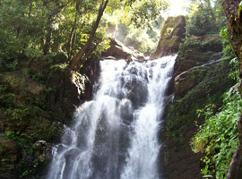
Shanti Falls
This is a beautiful waterfall on the way to Z-Point in Kemmangundi.
Hanumana Gundi Falls: Located 32 km. from the Kalasa, the waterfall has water falling on to Natural rock formations from a height of more than 100 feet.
Kadambi Falls: This is a waterfall located in the Kudremukh National Park.
Sringeri
90 km west of Chikmagalur town is Sringeri situated on the banks of Tunga, a Vedic Peetha established by Sri Adi Shankara, the exponent of the Advaita philosophy in 9th Century A.D. It is famous for Vidyashankara Temple originally constructed by the Hoysalas and later completed by the founders of the Vijayanagar Empire and Sharada temple, an early 20th. century addition. In the Vidya Shankara shrine, there are 12 zodiac pillars, which are so constructed that the rays of the sun fall on the pillar corresponding to the month.
Horanadu
Horanadu is 100 km southwest of Chikmagalur and has an ancient Annapoorneshwari Temple, which has been renovated recently. With the installation of the new image of Adi Shakti, now the temple is called Adi-Shaktyatmaka Shri Annapoorneshwari. The place attracts lots of pilgrims who are provided free boarding and lodging by the temple.
Guru Dattatreya Baba Budan Swamy Darga
Situated on the Baba Budan Giri is the Inam Dattatreya Peetha venerated by the Hindus and the Muslims alike. A laterite cave here is believed to have been sanctified by the residence of Dattatreya Swami as well as Hazrat Dada Hayat Mir Khalander. The worship here is conducted by a fakir and the annual jatra or urs is attended by both Hindus and Muslims with great fervors.
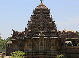
Amritapura
67 km north of Chikmagalur, Amrithapura is known for the Amritheshwara temple built in 1196 A.D by Amriteshwara Dandanayaka, a general of the Hoysala ruler Veera Ballala II. Delicacy of touch, originality of design and fine features have made this temple one of the notable structures of the Hoysala period.
Belavadic
Located 29 km southeast of Chikmagalur town on the Chikmagalur-Javagal road and 10 km north west of Halebidu, Belavadi is famous for Ornate temple of Veeranarayana. Belavadi is also famous for the temple of 'Udbhava Ganapathi'.
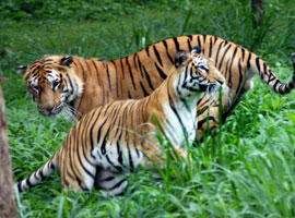
River Tern Nestling in Bhadra Wildlife Sanctuary
Occupying 495 km². of wildlife sanctuary and Project tiger reserve, this region is an important watershed of the Tungabhadra river. The huge reservoir here is the main water supply to several districts in the rain shadow regions of south Karnataka. The forests here are rich in Bamboo and birds species unique to both the Malabar and Sahyadri ranges.
Kudremukh National Park
The Kudremukh National Park (latitudinal range 13°01'00" to 13°29'17" N, longitudinal range 75°00'55' to 75°25'00" E) is the largest declared Wildlife Protected Area (600 km²) of a tropical wet evergreen type of forest in the Western Ghats. The Western Ghats is one of the twenty-five hot spots identified for bio-diversity conservation in the world. Kudremukh National Park comes under the Global Tiger Conservation Priority-I, under the format developed jointly by Wildlife Conservation Society (WCS) and World Wide Fund-USA.
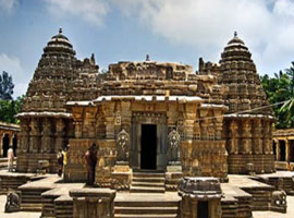
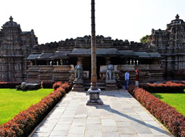
Chennekeshava Temple
Is the main temple in Belur and is only one at the three major Hoysala sites (the other two being Halebid and Somnathpur), that is still in daily use. Begun in 1116 to commemorate Hoysala's victory over the Cholas at Talakad, it took a century to complete. It is said that every major deity in the Hindu pantheon is represented on this temple. What is remarkable about this shrine is its compact structure, and perfect proportions. The wealth of sculptured friezes is simply unbelievable, since from the base to the projected eaves, every inch of available wall surface is covered with the most exquisitely sculptured images. On the inside of the temple, superb carving decorates the hand-lathe-turned pillars and bracket-figures on the ceiling. Each round filigreed pillar is different in details. Outside the temple, on the vimana, the Hoysala sculptors have surpassed themselves - unending rows of nearly 650 elephants, horses lions, birds and warriors. The larger panels of the wall sport scenes depicting the great epics - Ramayana and Mahabharata.
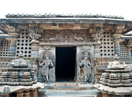
Halebid
Located 17km east of Belur, was the ancient capital of the Hoysala Empire. Founded in the early 11th century as Dwarasamudram (Gateway to the seas), it was destroyed by the armies of the Delhi Sultanate in 1311 and 1327 AD, after which it was deserted and later renamed Halebid (Old Capital).
The Hoysaleswara temple at Halebid, the largest of the Hoysala temples, was started in 1121 AD, about 10 years after the temple at Belur, but despite 86 years of labour, it was never completed. Nevertheless it is easily the most outstanding example of Hoysala art. Every centimeter of the outside walls and much of the insides are covered with an endless variety of Hindu deities, stylised birds and animals and friezes depicting the life and times of the Hoysala rulers.
Halebid also has a few other temples - the Kedareswara, though a dilapidated shrine, has is a classic example of Indian temple architecture. There is also an enclosure containing three Jain bastis (temples), the main being the Parsvanath Temple, with its 32-pillared pavilion. The 14 feet high image of Parsvanath has a seven-hooded cobra over its head. The two other shrines are those of Adinath and Shantinatha, though smaller, are elegant structures.